Earlier this week the Calvert Amateur Radio Association (CARA) hosted
its monthly meeting with a program by a local guru of mesh networking.
Keith KB3TCB gave a presentation on what mesh networking is and what it
can be used for. I've known about mesh networking for some years but
never found enough people in my local area that also found the idea
intriguing. Since moving to Calvert County (MD) I've discovered a lot
of people that are interested in experimenting with different things,
mesh being one of them.
Many club members went out and purchased gear to use as a mesh node and
brought their gear with them. I brought a Ubiquiti M2HP Bullet with a
14dBi-gain antenna. Using the firmware provided by
Broadband-Hamnet everyone's systems
almost immediately linked up with everyone else's and advertised
services could easily be consumed. I cranked up httpd and hosted my
Fedora test page (I'll try to do better next time with some actual
content). It would seem that there are many people that would like to
try experimenting with the technology.
Keith stressed that line-of-sight was very important to making contact
with others. I, personally, am used to Eastern North Carolina where a
hill is something seldom seen. Calvert County is not Eastern NC. I
figured that since I was about a mile and a half from the K3CAL
clubhouse that I should be able to easily make a connection there
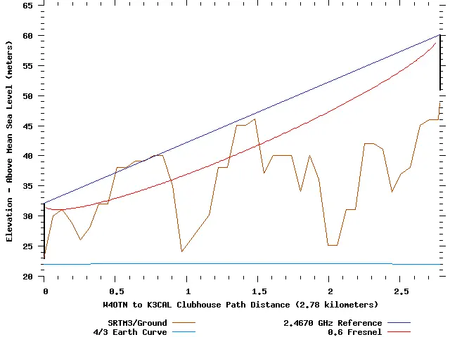
(through the trees). A quick check of the path finder yielded other
results.
[caption id="attachment_533" align="aligncenter"
width="640"] Microwave path
between W4OTN and K3CAL.[/caption]
Of course this assumes 30 feet of elevation on each end but you can see
that there is clearly a plateau in the way of my line-of-sight and
several geographic features in the way of my Fresnel path. Wow, I was
not expecting that. Turns out, the K3CAL side would need to be up
around 150 feet to make it over the hills (and we'd still have to deal
with the trees) or we'd both have to raise our antennas up to around 50
feet (doable?).
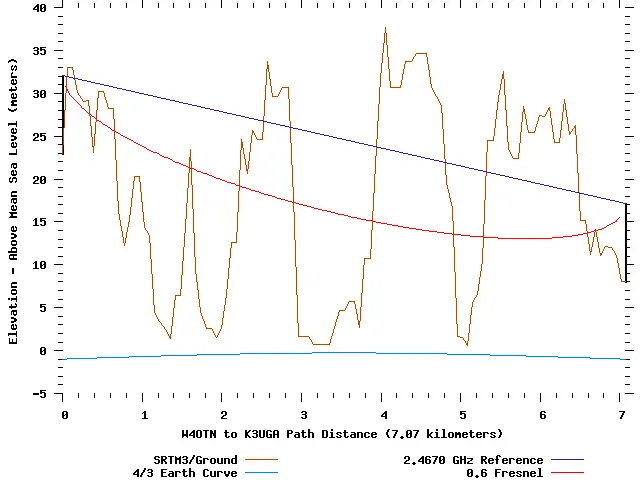
I ran into similar surprising results when calculating paths to a couple
of friends. On friend, Jim K3UGA, seems impossible to reach without
help of some infrastructure up high:
[caption id="attachment_535" align="aligncenter"
width="640"] Microwave path
between W4OTN and K3UGA.[/caption]
And so it seems I'll be learning what line-of-sight truly means here.
I'm not waving the white flag on my experimentation but rather setting
my sights (sites?) a little higher.