There are several radio contests that I look forward to each year. The ARRL June VHF Contest is one of those, and I’m happy to report a successful rover operation for the year.
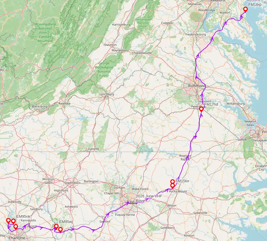
In the past I have roved up the DelMarVa Penninsula or started in western Maryland, but this year I would be starting in Charlotte, North Carolina. I made a plan before leaving, but that plan basically went out the window once weather and time came into play. Still, I was able to activate six grids (EM95, FM05, FM15, FM16, FM17, and FM18) and put sixty (60) contacts in my log. Unfortunately, the main band of the contest, six meters, wasn’t part of my rove plan due to antenna and radio complexities, but I was on two-meters through twenty-three centimeters! I should have that pesky six-meter piece figured out before September.
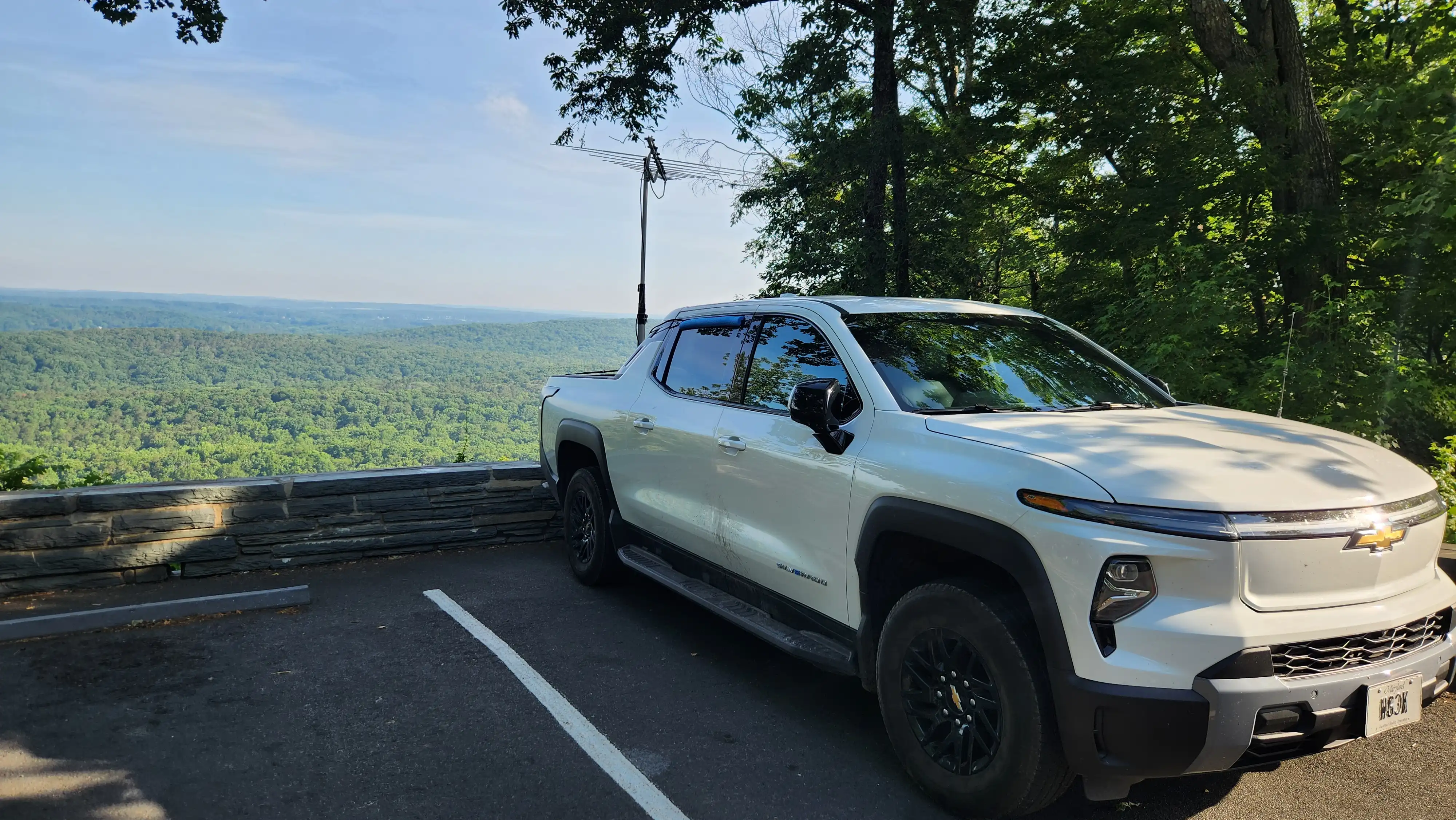
All contacts were made using a Q5 Signal Five-Band Transverter with 25w output (10w on 1296MHz), and a slightly modified Create CLP-5130-1N log periodic antenna that, for our purposes, provides two meter through twenty-three centimeter band coverage.
The Rove
Morrow Mountain State Park
I started my rove in EM95 near Charlotte on Saturday at 18:39Z, but didn’t officially hit the road until Sunday morning a little after 11:00Z. My first stop on Sunday was Morrow Mountain State Park in EM95wj. This is an great spot to hike, explore, and sight-see. Unfortunately, I did none of those things as I was after only one thing: altitude. The summit isn’t incredibly high, topping out at 276m (905ft) with a HAAT of 114m (374ft), but does provide unobstructed views in all directions. From here I worked stations in Georgia, Maryland, North Carolina, Ohio, South Carolina, Tennessee, and Virginia. Best DX was N8GA at 616km (382mi).
Before leaving Morrow Mountain, Dex W4DEX alerted me that I would be entering FM05 soon after crossing the Pee Dee River on NC-24. While he couldn’t give me any specific guidance on where I should set up, he said there were several ridge lines that might be amenable. After crossing the river I kept an eye on my GPS and watched the numbers get closer to the next grid. Dex was correct that there were a couple of ridge lines that the highway crossed just inside of FM05 and I stopped at what felt like the highest one.
Uwharrie National Forest on NC-24
I’m going to call this spot Uwharrie National Forest on NC-24, for our purposes. The spot is located at FM05ah36 and appears to be at 167m (550ft), according to the topo maps. It is shaded to the north and south by bumps that extend 45m (150ft) higher than where the road is located, but I was only looking for a place to work some of the locals before completely heading out of North Carolina’s piedmont. From here I worked stations in Georgia and North Carolina. Best DX was W4MAA at 392km (243mi).
After leaving Uwharrie National Forest, I just drove. I didn’t want to spend too much time getting through FM05 on my way home. I stopped just east of Zebulon to investigate a spot in FM05uu, but immediately determined the site wouldn’t be suitable. In-not-quite-a-panic, I called Andy WA4BRX to see if he could find me something I could use nearby. He came up with two perfect sites: Nash Community College (FM15bx) and Ennis Park (FM16ba). These will be going into my list of rover sites to be sure.
Nash Community College
Nash Community College sits just west of Rocky Mount along US-64. At the north end of the campus, near the highway, is a little bump (FM15bx) that was once measured to be 70m (232ft) in height. That is high enough to get above the average terrain of Eastern North Carolina. I didn’t stay here too long, but was able to work three stations on multiple bands, including WS4WW in Virginia, AA4ZZ in North Carolina, and WA3DRC in Maryland. Best DX was 354km (219mi).
Ennis Park
Ennis Park is a county park in Red Oak (FM16ab). This spot was less than ten minutes from Nash Community College, meaning I didn’t even have time to get out of my rover mindset before pushing my antenna back into the air and trying to make contacts. This park isn’t really high in altitude, but offers really good low-angle takeoff clearance as there aren’t many trees around. I was able to work stations in Maryland, North Carolina, and Virginia from here without trouble. Best DX was 350km (216mi).
Somewhere south of Petersburg
Two things were deciding factors on this next stop. First, I was ready to get home, but still hours away. The second was the weather. The Storm Prediction Center had already posted a Severe Thunderstorm Watch for the parts of Virginia I was getting ready to drive through, but I didn’t have much choice on my route home. As I approached Petersburg from the south, a Severe Thunderstorm Warning was issued for Richmond, just to my north. A pause might be good here (FM17hd).
I found a kinda high spot that had okay takeoff back towards Western North Carolina. Once I pulled into the gas station, I was able to quickly set up and work a few stations in Maryland, North Carolina, Pennsylvania, and Virginia. I wouldn’t necessarily recommend this place for a rove, but it did work in a pinch. Best DX was 400km (248mi).
I quickly got back on the road only to be met with lots of very heavy rainfall. The interstates were a mess and we weren’t moving as quickly as I had hoped. Once I got north of Richmond, the skies cleared a bit (I think all the storms were headed to Hampton Roads), and I was able to make it back to Maryland before it got too late.
Huntingtown
When I was almost home (FM18rn), I called WA4BRX/R on two meters and quickly worked from my sixth roved grid! It was also nice to put my home grid in the log as I hadn’t heard anyone from FM18 all day!
I pulled up at home and rolled out of my rover vehicle. I did try to clean it out a bit, but figured I’d get to it later. I was tired.
I’ve had fun going through all the data I created in these contacts. Thank you to all the stations that I worked, especially those that stopped what they were doing to run the bands with a rover. Already thinking of ways to improve my next rover effort (stacked beams and a kilowatt amp, right Dave?).
All logs have been compiled and uploaded to Logbook of the World and the POTA website. If anyone needs a QSL card for a contact made during the contest, just send me one and I’ll get one out to you ASAP!
Noteworthy Contacts
AA4ZZ (KC4PHJ)
The multi-op group of AA4ZZ was at it again from Boone, North Carolina. While not particularly DX, their location is awesome. An old friend (well, he’s not really that old…) Alex was operating with the group and made sure I was prioritized when I got in a spot to operate. I ended up working the group in every grid I visited (except for FM18).
W4DEX
Dex is a great resource for radio amateurs. He followed my progress on APRS and was ready to work me on five bands when we were in range. Unfortunately, I got out of range pretty quickly. Still I do enjoy working the higher bands when I can and Dex makes it fun.
WA4BRX
Andy wasn’t just my last contact of the contest, he also expertly routed me to two really good spots that yielded new grids for several ops. It sounds like he had a fun contest with all his gear, too.
Summary
Here are some of the big numbers:
-
Grids worked: 18
-
Grids worked from: 6 (EM95nk, EM95mk, EM95ni, EM95wj, FM05ah, FM15bx, FM16ab, FM17hd, FM18rp)
-
States worked: 7 (Georgia, Maryland, North Carolina, Pennsylvania, South Carolina, Tennessee, and Virginia)
-
Total Contacts: 60
-
2m Contacts: 30 in 17 grids - Best DX N8GA 616Km (382mi)
-
1.25m Contacts: 13 in 5 grids - Best DX N8LRG 560km (347mi)
-
70cm Contacts: 13 in 5 grids - Best DX AA4ZZ 400km (248mi)
-
33cm Contacts: 2 in 1 grid - Best DX W4DEX 49km (30mi)
-
23cm Contacts: 2 in 1 grid - Bext DX W4DEX 49km (30mi)
-
Multipliers: 27+6 = 33 (Limited Rover)
Stations worked more than once:
-
AA4ZZ - 15
-
W4DEX - 10
-
WA3DRC - 6
-
K1RZ - 4
-
KI4M - 3
-
WA4BRX/R - 2
-
W8ZN - 2
-
N8LRG - 2
-
WA4LDU - 2
Calculated Score:
-
Limited Rover - 2,706
Lessons Learned
-
Have back up spots and realize that making stops at or near grid lines is more efficient.
-
Six meters is a money band. Don’t leave home without it.
-
Figure out a way to make contacts while in motion. (This will likely be fixed using the UJB plan.)
Notes
Score Calculations
Grid |
2m |
1.25m |
70cm |
33cm |
23cm |
EM83 |
Y |
||||
EM84 |
Y |
||||
EM85 |
Y |
||||
EM86 |
Y |
||||
EM92 |
Y |
||||
EM93 |
Y |
Y |
|||
EM95 |
Y |
Y |
Y |
Y |
Y |
EM96 |
Y |
Y |
Y |
||
EN80 |
Y |
Y |
|||
FM05 |
Y |
||||
FM07 |
Y |
||||
FM09 |
Y |
||||
FM14 |
Y |
||||
FM17 |
Y |
||||
FM18 |
Y |
Y |
|||
FM19 |
Y |
||||
FM28 |
Y |
Y |
Y |
||
FN10 |
Y |
||||
Total |
17 |
5 |
5 |
1 |
1 |